Monday, January 7, 2013

AZ SR-77 Snowflake

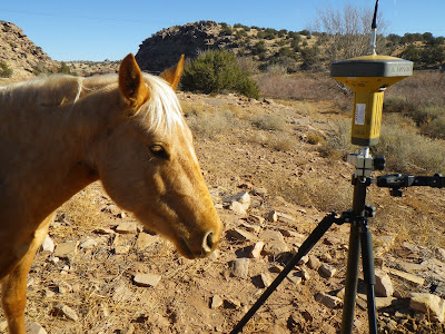
As the cold winds of December whipped around the high desert, we began a 1 mile survey of AZ State Route 77 heading North from the small Mormon town of Snowflake, AZ. We had done a project there in the past and we were to connect to that project in the course of our current survey. With morning temps in the teens, it brought me back to those winter mornings surveying in Flagstaff. The project turned out to be straight forward with a mix of new and old survey monumentation. The original highway boundary was marked with inverted pieces of railroad rail. The land in this area is in the valley created by Silver Creek and has been cultivated or used to raise cattle. While taking a reading on a point near the creek, I had a curious visitor. Eventually I had to shoo him away as he started to chew on the leg of my tri-pod! We had great weather and the work went smoothly. The high desert grasslands are beautiful in the late afternoon light. On the last day, a huge snowstorm rolled in and we had to abandon the last bit of work left to do. We drove over the mountain just in time to get back down into the rain of the low desert valley. Google Earth Lat/Long: 34°31'20"N,110°04'47"W

Wednesday, October 26, 2011

AZ SR-260 Overgaard - Willow Wash

In August, we began mapping an 8 mile portion of SR-260 heading East from Bison Ranch in the quaint hamlet of Overgaard, AZ. Traditionally a heavily forested stretch through rolling hills and washes, this area was heavily damaged by the Rodeo Chediski Fire in 2002. This gave the job a very interesting and diverse natural landscape as well as aiding us in our use of GPS, which is normally hampered by heavy tree cover.


During the Control Survey, we occupied an NGS Control Station at the base of Deer Springs Fire Lookout.


In late August, the monsoon is fading and all of the plants, animals and insects are out to catch that last bit of summer sun.


With the fire wiping out a good portion of the tree coverage, the re-emerging life has more desert type plants returning. Against a backdrop of Denrda-skeletons, the new growth is greatly contrasted.


The fire certainly had its effect on the survey monuments and accessories as well. When in a forest, the section monuments are witnessed by bearing trees. We found these trees in all sorts of conditions; Burnt but standing, burnt and laying down, signage melted to the tree. The heat also caused some of the monuments themselves to droop over.


Yet, in many places we found everything in tact and un-disturbed like this survey stone set in 1883.


I've driven though this area many times on the way to Pinetop and never would have considered that it would be so interesting to hike around in the burn area. After 10 years of recovery, the mix of old forest and new growth was really a pleasure to see up close.


Google Earth Lat/Long: 34°22'46.20"N,110°28'19.00"W

Monday, June 20, 2011

Sunnyslope "S" Mountain

My company was asked to do a boundary survey and location map of "S" mountain in the Sunnyslope Village of Phoenix. After spending a few days surveying the boundary by myself, I got a chance to take my brother in law Michael up on the mountain to survey the "S".


Google Earth Lat/Long: 33°34'25.38"N,112°04'35.50"W

Wednesday, February 2, 2011

AZ SR 89 - Little Hell's Canyon

This January (2011), we began a project located 15 miles south of Ash Fork AZ. This portion of AZ SR 89 lies in the rolling juniper covered foothills southwest of Bill Williams mountain. What was originally the Prescott & Ash Fork Stage Coach Road, has only changed by the asphalt arming the same location. Closely skirted by the Prescott spur of the Santa Fe railroad, this area has a close and mostly undisturbed tie back to the foundation of Arizona itself.


The old SR 89 bridge closely paralleled by the current Santa Fe rail bridge over Little Hell's Canyon.

This area is at the headwaters of the Verde Valley and offers some amazing views.

Looking Northeast towards Bill Williams Mountain.

Having been originally surveyed by the U.S. General Land Office in 1884 and having been inducted into the Prescott & Kaibab National Forests, the area has laid untouched since that time. As surveyors, we expected to find the original stone survey monuments as well as bearing trees from the 1884 and subsequent 1910 surveys in pristine condition. We certainly did.


Original Stone Survey Monument with etchings over 100 years old.


Bearing Tree of the same vintage.

Only 3 miles in length this is a relatively small project for us, but we found ourselves wishing it was much longer.


Google Earth Lat/Long: 35°04'51.96"N,112°24'18.38"W

Monday, January 17, 2011

The Strangest of Sights.......

This past week I was tasked with staking the new Right of Way line for a portion of a new major freeway in the Valley. At the end of the day I began to recount all of the random places I found myself and things I saw. I decided it added up to one of the most multifarious days of surveying I can remember.


A Rose Farm


An Olive Tree Farm


A Palm Tree Farm


Low Flying Air Force Training Fighter Jets


And Yes, A Rhinoceros!


Google Earth Lat/Long: 33°33'11.50"N,112°25'06.55"W

Wednesday, December 15, 2010

AZ SR 78 - Jake's Corner... Finalized


This week, we set the final Right of Way monuments on SR-78 in Greenlee County, AZ. This brings to a close a project we have worked on since 2005. I'm very glad to have worked on this project as it brought me to another remote and extremely scenic area of Arizona. Only a very small portion of Highway 78 actually lies in Arizona as it crosses into New Mexico shortly after its beginning at 3-Way.


The project was nestled into a small basin atop this mountain (Big Lue Mountain) that was filled with Ponderosa Pine, Alligator Juniper, and small cacti all mashed together in a micro-climate caught between desert and forest.
Only a mile long, this project posed several new survey challenges and gave us a few stories that have become GMTS lore.


Google Earth Lat/Long: 33°04'20.14"N,109°04'57.89"W

Friday, December 10, 2010

Fall Colors In Phoenix....

Yes, mid- December is fall here in the desert. The colors are changing and the birds of the North have migrated here for the winter.


I spent this past week setting the final ADOT Right Of Way monuments for the Loop 101 - Loop 202 Interchange in Tempe.


We set a 24" long steel hex rod with a 3" aluminum cap for these.


I also got a chance to test the timer on the new digital camera.


Google Earth Lat/Long: 33°26'02.58"N,111°53'27.19"W