As the cold winds of December whipped around the high desert, we began a 1 mile survey of AZ State Route 77 heading North from the small Mormon town of Snowflake, AZ. We had done a project there in the past and we were to connect to that project in the course of our current survey. With morning temps in the teens, it brought me back to those winter mornings surveying in Flagstaff.

The project turned out to be straight forward with a mix of new and old survey monumentation. The original highway boundary was marked with inverted pieces of railroad rail.

The land in this area is in the valley created by Silver Creek and has been cultivated or used to raise cattle.

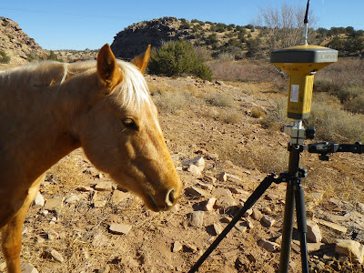
While taking a reading on a point near the creek, I had a curious visitor. Eventually I had to shoo him away as he started to chew on the leg of my tri-pod!

We had great weather and the work went smoothly. The high desert grasslands are beautiful in the late afternoon light.

On the last day, a huge snowstorm rolled in and we had to abandon the last bit of work left to do. We drove over the mountain just in time to get back down into the rain of the low desert valley.


Google Earth Lat/Long: 34°31'20"N,110°04'47"W
 The project turned out to be straight forward with a mix of new and old survey monumentation. The original highway boundary was marked with inverted pieces of railroad rail.
 The land in this area is in the valley created by Silver Creek and has been cultivated or used to raise cattle.
 While taking a reading on a point near the creek, I had a curious visitor. Eventually I had to shoo him away as he started to chew on the leg of my tri-pod!
 We had great weather and the work went smoothly. The high desert grasslands are beautiful in the late afternoon light.
 On the last day, a huge snowstorm rolled in and we had to abandon the last bit of work left to do. We drove over the mountain just in time to get back down into the rain of the low desert valley.

 Google Earth Lat/Long: 34°31'20"N,110°04'47"W


